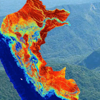
Scientists unveiled the first high-resolution map of carbon stocks stored on land throughout the entire country of Peru using a new methodology with implications for managing future market-based carbon economies. The carbon map and accompanying report are the result of a MacArthur-supported project led by the Carnegie Airborne Observatory. Using airborne laser mapping technology, the scientists found the largest stocks of carbon are in the North Peruvian Amazon and along the border with Brazil, while regions of deforestation in Peru had little to no carbon storage at all. This new information now allows decision makers in government to better manage land-use and forest protection.